


 On the François Kauffer map dated 1776, the name of the Cape of Moda, at the southernmost end of the land covered with large green areas, is shown on this map.
It was designated as “Mondi Bournou” (Nose of Worlds).
The engraving of the building and its surroundings, which is designated as "Kiosk" on François Kauffer's map, drawn by the French Royal painting and engraving artist J. Goubaud between 1822 and 1825, looking from the ridges of Mühürdar.

This engraving is by Marie-Gabriel-Florent-Auguste de Choiseul, who was in Istanbul as the French ambassador between 1784-1791, in the "Picturesque Voyage of 1819" published in Paris by the Brussels publisher Innocent-Louis Goubaud (1770-1847). It is one of the 49 engravings in his book “Constantinople and the banks of the Bosphorus” (Picturesque Journey to Constantinople and From the Bosphorus shores).
François Kauffer, together with the French archaeologist, astronomer and traveler Jean-Baptiste Lechevalier (1752-1836), reconsidered, confirmed, revised and published the map he had drawn in 1776 in 1786 and then again in 1803. On these maps, this time, Moda Cape was designated as “Monde Bournou” (World Cape), and it was also shown that construction had begun, albeit sporadically, on these maps.


On the map dated 1788, Cape Moda is again indicated as Cape Mondi and only a Mansion is specified in Mühürdar.

In this map, in the small settlement on the coast, the mosque built in 1612 on the site of today's Osman Ağa Mosque and Sultan III in 1747. Iskele Mosque, built by Mustafa, draws attention as monumental structures. Behind them is the Church of Saint Euphemeia in the town.

1819 by François Kauffer and Jean-Denis Barbié du Bocage
Moda Cape on the Istanbul Map.

Moda on Istanbul Map by Franz Fried (1811-1868) of Austria, dated 1821.
Before being appointed as the secretary of the French ambassador Marie-Gabriel-Florent-Auguste de Choiseul in Istanbul between 1784 and 1791, Jean-Baptiste Lechevalier visited Italy and Anatolia and conducted and published archaeological studies on these regions.
Jean-Baptiste Lechevalier aimed to discover Troy in 1785-1787, after his archaeological research on the Troad (Biga Peninsula), he went on another journey in 1787, which included Moldavia and Wallachia regions, and visited the Black Sea coasts during his stay in the region. Jean-Baptiste Lechevalier, during these studies in Anatolia, Hellespont (Canakkale Strait), Bithynia [North of Anatolia, Black Sea in the north, Phrygia (Phrygia) in the south, Galatia (the region between Kızılırmak and Sakarya, the center of which is Ankara), Propontis in the west. (Marmara Sea), the geographical area where present-day Bolu, Kastamonu, Bursa and Zonguldak provinces are located] and Propontis (Marmara Sea) regions, bounded by Paphlagonia (Bartın, Amasra, Kurucaşile, Cide region) and Galatia in the east, and also detailed information about the Bosphorus. provided topographic data and described Roman, Byzantine, and Ottoman monuments in Istanbul. In addition, together with the French Army engineers André-Joseph Lafitte-Clavé and Joseph-Monnier*, they made geographical observations about the Euxine Pontus (south coast of the Black Sea) based on the data they collected, and drew detailed maps of all these regions.
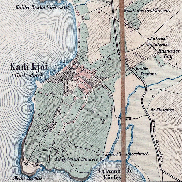
Kadıköy, Mühürdar and Moda on an Untitled Map of Istanbul Dated 1860
The most striking change in this map, which is understood to have been made after 1860, is that a visible settlement has occurred in today's Mühürdar and Moda districts. The land from Pier to Moda and Yoğurtçu is still in gaps. However, starting from Mühürdar along the coast, Moda, Küçük Moda and Şifa, residences were built, albeit sparsely, to the exit of Kurbağalıdere.

Carl Stolpe's map of 1882
In the second half of the 19th century, maps of Istanbul became widespread. This was due to the increasing number of European tourists arriving in the Ottoman capital. In this period, maps of Istanbul, drawn by Prussian officer Carl Stolpe, starting from the 1860s, were also included in the travel guides targeting the tourists coming to the city. The edition of the maps published by Lorentz & Otto Keil* in Istanbul was accompanied by French and German explanations with a wealth of information about historical sites. The different colors clearly indicated the various parts of the town, "according to their religious composition" and cemeteries. In later editions, the blue lines also indicated urban and interurban railways. Stolpe's maps proved successful by going through numerous editions by the end of the century.
 International Bookstore OTTO KEIL, Grand Rue Pera No:457, Opposite Passage Oriental (East Passage), ISTANBUL
(pictured) Lorentz & Keil promotional advertisement in the 1881 "Annuaire Oriental" Oriental Yearbook.
Otto Keil “Kayl”, known as the “Fournisseur du Sultan”, the Sultan's supplier (Palace bookstore), was one of Pera's leading booksellers and publishers, and was a frequent destination for high-ranking Ottoman bureaucrats. At the same time, he was also editing postcards and preparing albums. Otto Keil was also selling books to the Ottoman Palace during the reign of Sultan Abdulhamid.
In this map of Carl Stolpe dated 1882, it is seen that the Anatolian Baghdad railway is being built. The construction of the railway and Haydarpaşa Station caused the development of Kadıköy, especially the Yeldeğirmeni region, which was heavily covered with residences. Another striking point on the same map is the presence of two mansions in Mühürdar and Moda. The mansion in Mühürdar belongs to Serasker Rıza Pasha, and the other mansion in Moda belongs to the family of Alfred James Frederick Barker (later Mahmud Muhtar Pasha).
The same mansions can be seen in the 1887 map of the French Civil Engineer, J.Sloniewski. However, these maps are not at the correct scale to determine the exact locations of the structures. For this reason, it would be more correct to call them sketches rather than maps.
 1887 map of the French Civil Engineer J. Sloniewski
When we come to a later date, the English geologist, naturalist and ornithologist Hugh Edwin Strickland (1811-1853), who made a journey to Anatolia, Thrace and the Bosphorus, conducted research on the geology of Istanbul and its surroundings in March 1836.
“...While this was a very damning study, it was enough to show that the area was unexplored and that the brief geological surveys found in the work of other travelers were not very satisfactory. Therefore, I am forwarding my observations, however small, to the public in the hope that they can guide geologists who will be encouraged to explore this interesting region in the future...”
As an ornithologist as well as geology, Hugh Edwin Strickland also conducted research on the legendary Dodo, a flightless bird that was about 1 meter long, 20 kilograms, and went extinct towards the end of the 17th century, and also identified 33 bird species on the World Bird List today. had discovered.
Hugh Edwin Strickland, in the book “Memoirs of Hugh Edwin Strickland” published by William Jardine in 1858;
“...I went to Üsküdar and passed some magnificent barracks built by Sultan Selim, and following the cliffs, in the continuation of Kadıköy, which was built on the ancient Chalcedon (Chalchedon), which has no traces anymore, it is the favorite summer resort of the French in summer. (Cape of Monde) I have reached Cape Monde. Opposite this cape, which is a small bay in the south, there was another cape that formed the entrance of the Gulf of Iznik (the author here, looking to the south, either saw Fenerbahce Cape and said the Izmit Bay entrance, or meant the Armutlu Peninsula, which can be seen far ahead in clear weather). ”
He recorded that Moda Cape was called “Monde Bournou” in those years.
M O D A | Promo - Mondi - Monde - Mondo - Monda

A view of Fenerbahce through the Chitlembic trees right at the tip of Moda Cape.
It is understood that Moda Cape, which was called Promotu nose in ancient times, even in the Byzantine period, has been known with names such as "Mondi" or "Monde" in different languages since the 16th and 17th centuries, and these names have evolved into Moda over the years.

In the meantime, "Histoire De L', written by the Austrian Orientalist and historian Baron Joseph Hammer-Purgstall (1774-1856), who worked as a diplomatic translator in Istanbul between 1799 and 1806, was translated into French by JJ Hellert and published in Paris in 1843.
After the maps of Constantinople and its suburbs drawn by François Kauffer, Jean-Baptiste Lechevalier and Jean-Denis Barbié du Bocage between 1776 and 1786, included in the book “The History of the Ottoman Empire”, in which the changes that took place until 1831 were processed, the Moda His nose was designated Moda Bourni (Promontoire de Chalcedon). The words “Promontoire” in French and “Promontorium” in Latin mean “Nose”.

The houses built in Moda were different from the classical mansions, the Bosphorus mansions and the mansions in the Islands. Rich families living in Moda had houses built in different and individual styles, most of them in gardens, usually two-story. Although fashion exhibited an eclectic architectural appearance in a sense, it had a common character in the whole.
Kadıköy and especially Moda started to develop in the second half of the 19th century. A residential texture was formed, consisting of the large mansions in the garden of the pashas of the Abdülhamid period. After the First World War and the establishment of the Republic, the mansions belonging to the local pashas and foreigners, which formed the aforementioned texture, started to decline gradually by changing hands. From dozens of mansions, mansions and houses with gardens, very few examples have survived to the present day. One of them is Sarıcazade Arif Paşa Apartment and the other is Mahmud Muhtar Paşa's Marble Mansion.
Source: https://lcivelekoglu.blogspot.com/2020/03/kadkoy-modada-bir-deli-sarayl-i.html

James William Whittall (Vitol) Tower House, who was married to Edith Anne Barker, sister of Alfred James Frederick Barker, in 1870, on a large land on the slope descending from Moda Street to Moda Park, overlooking Istanbul's Sarayburnu, within very large gardens. He had a mansion built known as (Tower House). James William Whittall, the wooden mansion (in the aerial photo below) which was built next to the Tower House and which was larger than Whittall's Tower house, belonging to Zannis Stephanovich* (Stefanović, 1806-1886), a magnate of the Balkan Skylitzis (Schilizzi) family. ) to his eldest son, Frederick Edwin Whittall, and his daughter-in-law Adèlaïde Helen (La Fontaine) Whittall (1867-1948), who had 12 children.
The name of the street that we know today as Patrol Street, which goes down to the sea along the grounds of the mansion, is still indicated as Stefanovitch Street on the maps dated 1913, known as the German Blues, despite the passing of years.
Zannis Stephanovich Schilizzi competed with Yıldız Palace Doctor Sarıcazade Arif Pasha, who had coveted the place of this wooden mansion, during the purchase of this wooden mansion, bought the land and had this mansion built despite his financial and political influence. Losing this land greatly angered Sarıcazade Arif Pasha, and by taking the large piece of land on the opposite side of the road opposite him, he had the architect Constantine P. Pappa built in 1903 the multi-storey stone mansion that stands out among the apartment blocks in Moda. Thus, even though Sarıcazade Arif Pasha could not own that land, he was content with the happiness of looking at the magnificent garden of Zannis Stephanovich Schilizzi and the sea view behind the mansion from the windows of the mansion he had built.
Later on, James William Whittall built large and small houses for his daughters and sons around it, within the large estate of the Tower House, almost creating a small Whittall duchy for himself and his large family.
Zannis [John (Eng.), Giovanni/Gianni (IT), Yanni(Tr)] Stephanovich Schilizzi, one of the leading bankers of Galata, who was born in Chios and has Italian citizenship, was founded in 1875 by Osman Hamdi Bey's Kadıköy Department of the Municipality. İzzet Efendi, Kirkor Efendi, Monsieur Lorando, Monsieur Tubini, Monsieur Korpi, Rıza Efendi. , Monsieur Dimitraki, Canik Ağa, Monsieur Ralli, and Abacıbaşı Ligor Efendi, as well as a member of the Municipal Council.
During the Ottoman-Russian War of 1877-78, when European banks turned their backs on Turkey, the Ottoman Government provided its money needs from local bankers and banks in Istanbul, and in return for these borrowings, the most important state revenues were given to them as collateral. On November 22, 1879, the Ottoman Government undertook to pay its debts to the Ottoman Bank and Galata bankers in 10 years through the "Rüsûm-ı Sitte" (Six Taxes) Administration, which was established by the Ottoman Bank and Galata bankers. fish showed revenues from alcohol and silk tax of some places. Ottoman Bank managers H. Forster, Emile Deveaux and Von Haas, and Galata bankers George Zarifi, Salomon Fernandez, Bernard Tubini, Eustache Eugenidi, Theodore Mavrokordato, A. Vlasto, A. Barker, Paul Stefanovich Schilizzi, Leonidas Zafiri, Georges Coronio, Zannis Stephanovich Schilizzi also took part in the management of Rüsûm-ı Sitte, which included Ulysse Negroponti and undertook the management of these six revenues.